MapCarte 369/365: Illustrated London by Mike Hall, 2011-present

MapCarte369_hallHigh quality linework and meticulous colouring give rise to clean cartography. In this age of web maps it’s good to see that illustrators still find value in crafting maps by hand to create one-off sheets. Mike Hall has been creating a series of maps of London’s Boroughs since 2011. This example of tower hamlets is an example of the skill with which he fashions beautiful, well balanced maps that combine detailed cartography with marginalia that harks back to historic maps.

The inclusion of crests, shields, illustrations and views of key places along with decorative borders and typography show mastery in layout that displays a keen sense of the importance of form as well as function. The map is intended to delight; to be seen and used as much as an artistic piece as a way of exploring the geography. Maps always did ‘fill in the gaps’ to create a whole that was greater than the sum of the parts and Hall brings the philosophy up to date with his creative cartography.

Each of the maps in the series riffs off particular themes or historical events from the Borough so each has a unique identity. As a set, they bring to life the rich variety of London’s landscapes as a tapestry of maps that reflect their very different characters.

Hall’s work goes beyond this series of maps. His isometric drawings and other map-based illustrations are equally impressive. Modern map-makers can certainly learn a few things about the art and craft of cartography by studying his work.

See this series of maps and Hall’s other work at his web site here.

MapCarte 344/365: Geographical Cards by Charles Hodges, 1827

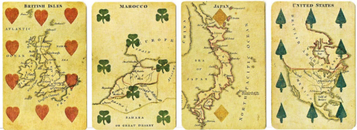
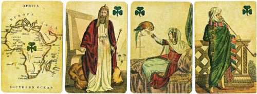
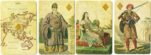
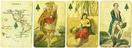
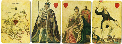
MapCarte344_hodges5English bookseller and stationer Charles Hodges original Geographical Cards were published in 1827 and subsequently in 6 different versions until c.1830 when he ceased trading. They have become highly collectible and prove the versatility of maps in their ability to suit a wide variety of purposes. Here, as a backdrop to the most simple of games – the humble pack of playing cards. To this point, there had been a tradition of creating playing cards with engraved representations of educational and scientific subjects. Hodges carried on this tradition by using maps as the focus of his own cards. The cards were made and manufactured by Stopworth & Son in London.

The Aces show maps of the four main continents of Europe, Asia, Africa and America. The court cards depict historical persons representing the continent and the other numerical cards show maps of the respective countries. George Washington is the King of Spades and King George IV is the King of Hearts.

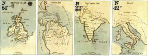
MapCarte344_hodges4 MapCarte344_hodges3 MapCarte344_hodges2 MapCarte344_hodges1The maps themselves are small format (obviously) but in this case small is beautiful and each map is exquisitely engraved and coloured. Coastlines benefit from a waterlining vignette and for such small maps, the typography is of a suitable level of detail and shows excellent positioning. In every sense, these are excellent maps albeit their primary purpose is illustrative in support of the deck of cards.

Hodges later made use of the same printing plates and produced a game using cards that had no suit information but, instead, had the longitude and latitude of capital cities printed as well as more elaborate colouring, particularly in the colour applied to the seas and oceans.

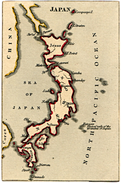
MapCarte344_hodges6He also produced a set of forty cards without suit marks or the court cards simply as a miniature atlas. These appeared in a small slip-case and had gilt-edges.

MapCarte344_hodges7Maps can be used in myriad ways and as a mechanism to provide not only an attractive illustration but also additional interest. A beautiful way of using cartography.

MapCarte 341/365: Mapping analogy for explaining to people the mingling and evolution of influences in the World Wide Web technology by Tim Berners-Lee, 2007

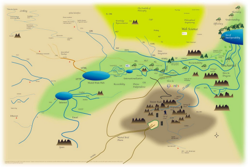
MapCarte341_leeIf I say that this map by Sir Tim Berners-Lee will never win any design awards then you’d be perfectly within your rights to question why it warrants a spot in MapCarte. That would be to ignore the map’s function which is to explain how the world wide web works to mere mortals…and the use of a map is a perfect metaphor. The complex world of wires that Berners-Lee is credited with inventing during his time at CERN. Of course, the world has grown way beyond those early beginnings and is far more complex with a range of complementary technologies which interlink in weird and wonderful ways.

The map, then, portrays these relationships and shows how various components connect together and what each is used for. Even if you have no idea what TCP is or how Google fits into the scheme of things this map gives you a sense that you can at least position them within. There are some wonderful touches and the map isn’t devoid of graphical treats. Google isn’t directly mentioned but the colour coding of the word ‘Giants’ is unmistakable and riffs off the logo. There’s also some vague areas thrown in that refer to accountability or logic or efficiency and understanding. There’s even a ‘here be dragons’ reference.

So what of the map’s overall appearance? Well it’s reflective of an early computer game aesthetic. It’s simple and clearly generated using simple paint tools. In many ways it works in this form where a more accomplished map or diagram might not. It reflects complexity through simple graphics. There’s no place to hide in this realm as depicted and the seas and mountains add to the sense of some sort of fantasy map, perhaps almost Tolkien-esque. Even the fonts used perhaps add to the impression that this is a role-playing game map. It’s a look and feel that works well.


MapCarte 304/365: They would not take me there by Michael Hermann and Margaret Pearce, 2008

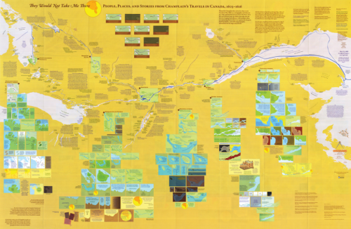
MapCarte304_champlainMaps are used for a wide variety of purposes to show something of a place, to tell a story or perhaps even to provide an insight into our imaginations. They can also be used very effectively to augment other works and materials to bring something new to the table. In this example, Pearce and Hermann have created a map that traces the story of Samuel de Champlain’s journeys in New France in the early 17th Century. It’s an example of a literary geography being brought to life through cartography.

The layout contains a very stark representation of the area of the St Lawrence River and part of the Great Lakes. The otherwise empty space is then filled with a multitude of small insets containing additional maps which act as stages in the journey. The result is both a fairly flat overall image but which contains depth and detail that one begins to see as they enter and explore the map – just as you might a good story.

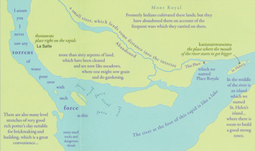
MapCarte304_champlain_detail1The map isn’t simply a collection of randomly placed map elements which the reader is somehow expected to piece together. The map itself enhances the story so that the travel and the story in the journal is given a spatial context through arrangement. The map provides an additional actor on the stage to give rise to a richer sense of the story as if Champlain is narrating the story through the map.

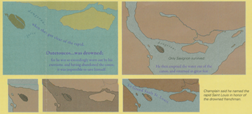
MapCarte304_champlain_detail2The design incorporates some elements that allow us to see different actors such as the native people’s thoughts and the map author’s comments which make the map an engaging commentary as well as a representation of the original journal. The conversations and incidents are brought alive through the map. Colour is also well played to give rise to an emotional response. Darker colours represents a more foreboding element to reinforce the narrative.

A great example of emotional and narrative cartography; of story telling and of using a map and all the visual stimuli of design to capture the imagination and to convey something more than the journal alone.

You can read more about the map from the author’s here and here and Daniel Huffman has written his own excellent critique here. Thanks to Daniel for suggesting this MapCarte entry.

MapCarte 271/365: Japan, the target: a pictorial Jap-map by Ernest Dudley Chase, 1942

MapCarte271_japan

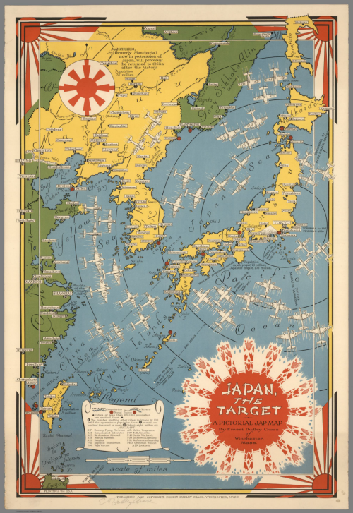
Pictorial maps often allow a certain degree of artistic license and can be extremely effective instruments of propaganda. This wonderful map from World War II by Ernest Chase uses colour and symbology effectively to create a graphically simple yet powerful image of Japan as a ‘target’. The colours clearly demarcate the enemy and the use of stylized Japanese rising sun symbology supports the notion of a threat posed.

Different aircraft types give a sense of superiority in the air and their flight paths diverge upon Japan provide an impression of wholescale attack and the enemy having little chance of either retaliation or defence. The aircraft are even drawn with the effect of movement and convergence to emphasise their rapid attack. Perhaps it’s the concentric circles drawn across the map that identify distances to various cities and between cities such as San Francisco and Manila that provide a sense of accuracy and precision as if the map could actually support military purposes.

Some general topographic detail is included as well as the location of naval bases. The hierarchy is well established and the map bleeds well into elements of the border. Overall a beautiful map and an example of the pictoorial style used to create a busy and evocative impression in the map readers mind.

MapCarte 266/365: Wonder map of Melbourne by John Power Studios, 1934

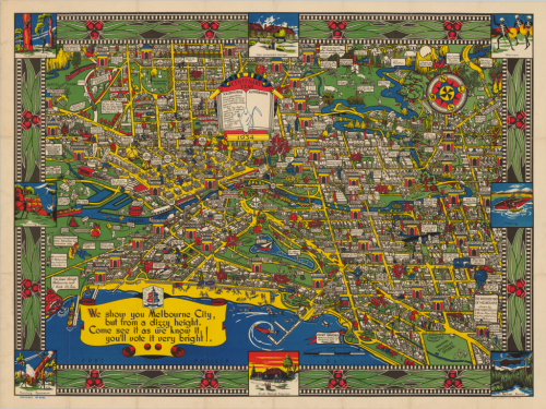
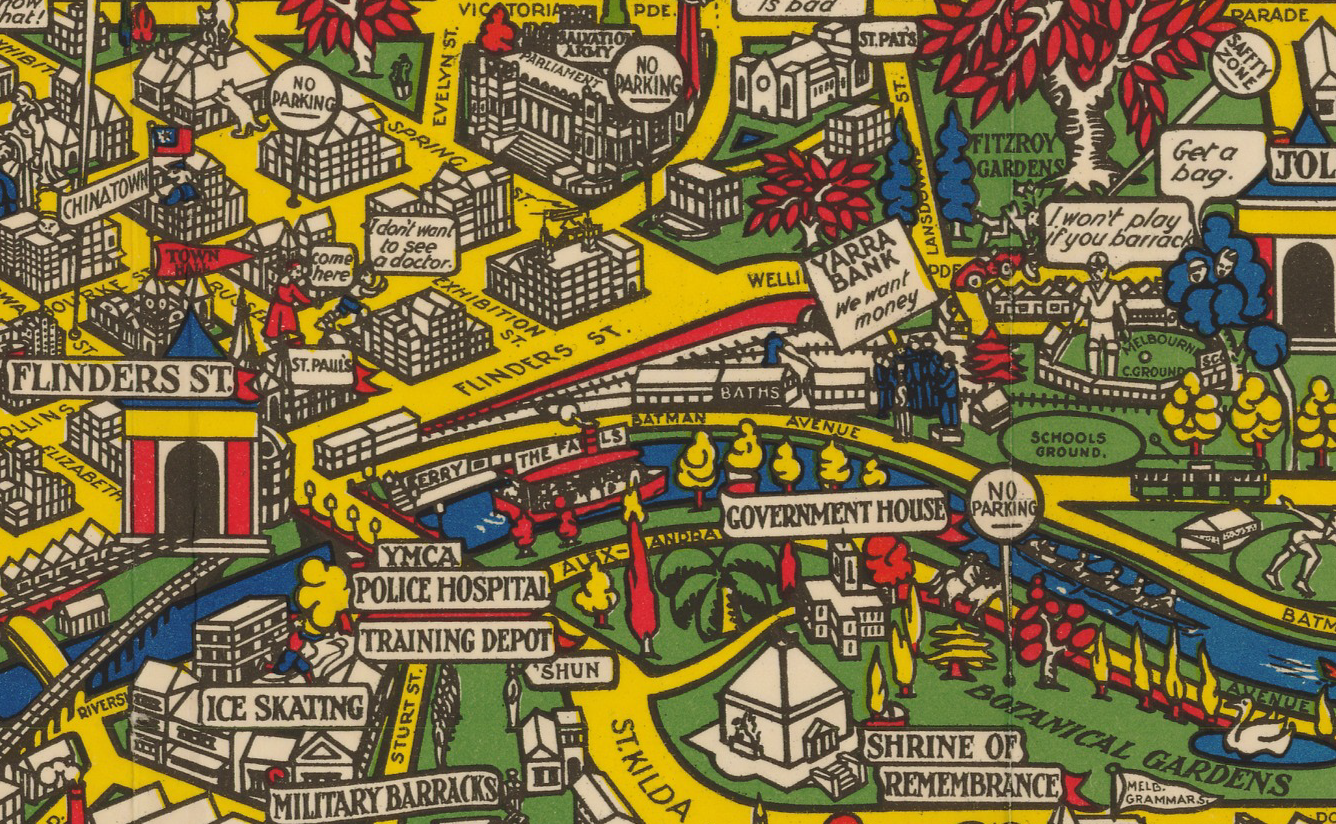
MapCarte266_melbourneIn 1914 Macdonald Gill drew his Wonderground map of London (featured in MapCarte 15). It brought a cartoonesque aesthetic to the streets of London and included pictorial elements and other delightful characters that produced a playful, whimsical but detailed and well marshalled map. Twenty years later, this map appears. It’s a map of Melbourne, Australia which displays a remarkable resemblance to Gill’s original. Considering we’ve already discussed Gill’s map, why is it necessary to include a derivative?

In design terms, there’s very little that is genuinely new in cartography. Most of what we seen owes something to what has gone before either in terms of some small element or, perhaps, in its overall style. Taken to extreme, derivative works can become merely pastiches (see the perpetual use of Beck’s subway map as a basis for alternative cartographies for instance) but sometimes they reflect an homage to a particular approach.  There’s a fine balance between homage, pastiche and plagiarism but here, the authors have shown a keen eye for their own landscape and geography and created a map in the style of Gill’s but with a clear Australian dimension.

MapCarte266_melbourne_detail

In this sense it’s worth promoting the idea that design doe not necessarily need to be wholly original to work. Many great cartographic effects and styles get re-used and re-imagined. New places and new ideas can add to the canon but in the main, maps tend to show subtle or blatant lineage.

MapCarte 260/365: Baseball Stadiums ArtMap by World Impressions, 1987

MapCarte260_artmap1

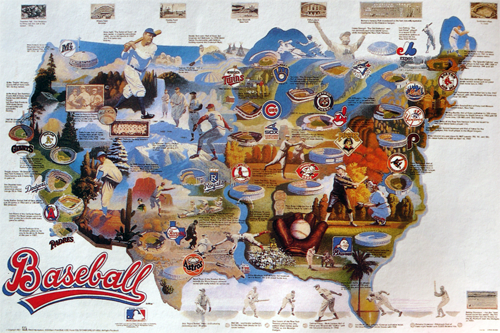
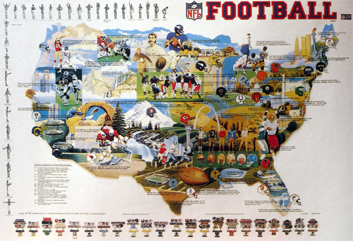
Pictorial maps are often some of the most artistic, combining illustrations of a theme to create a dramatic, attractive poster. They are commonly used to build a picture of a phenomena that perhaps draws people in who have some vested interest in the content…sport being a favourite theme for such maps because of the passion and association people bring to the map.

Here are two examples of maps by World Impressions that showcase the very best of the collage approach that incorporates key imagery from all teams. the first illustrates baseball and the second, American Football. The illustrations vary considerably from paintings of the natural landscape to key historic sportsmen to stadiums and team logos. The lack of uniformity creates interest and the poster allows a viewer of the map to immediately identify their own team as well as their opponents across a map that gives them an equal visual treatment.

MapCarte260_artmap2Textual components are minimal but the borders are well framed using allied imagery. Here we have a map that is designed simply to stimulate our passion for the sport and the teams we support. It shows where the teams are based but the spatial component is secondary to the emotional response the map is intended to invoke.

Done well, as these two maps are, pictorial maps can be attractive as pieces of art. They often adorn our walls and act as a reminder of our team and their place.


MapCarte 253/365: L’arsenal de l’apocalypse by Le Nouvel Observateur, 1991

MapCarte253_gulfwar


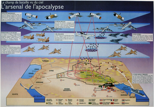
There’s nothing like conflict to get the cartographic juices of newspaper, magazine and television media flowing. It almost seems to ignite a battle to present the most compelling map or information graphic; one that brings together as much useful information in one dramatic illustration. The art in this is to ensure that clarity remains and to avoid the temptation to over-dramatise or place too much on the map. This is a challenge for cartography generally, but for a map that accompanies a newspaper article which is there as a supporting component to the story, the requirement to be prudent is paramount. The map needs to attract the reader to spend a few moments. It is a complement to the report. It doesn’t need to tell the whole story but it needs to contain the essential facts.

This French example from early in the first Gulf War shows how the balance can be achieved. there’s a tremendous amount of detail yet it’s illustrated in a clear, unimpeded fashion. The tilted block diagram is almost apologetic as the shape of Iraq is laid out amongst simple shapes of water bodies and mountains. But it’s the firepower from above that the article is emphasising as layers of armoury, missiles and satellite technology pour over the landscape. Scale is irrelevant. This is about showing the blanket capabilities of the allies. The illustration of bombs dropping through a clean-cut hole in the sky and those fired from the warship in the gulf itself are clinical. The laser-red of the satellite monitoring gives us a sense of precision. Of course, war is anything but clinical, clean and precise but these sort of illustrations present us with a sanitised version that explains the technology being used.

The maps used in such graphics are merely the canvas upon which a story is told but they are the crucial element. Combined with high quality illustrations, media maps do a good job of putting maps in front of many thousands of people.

MapCarte 207/365: Transatlantic Superhighway by John Grimwade, 1996

MapCarte207_grimwade


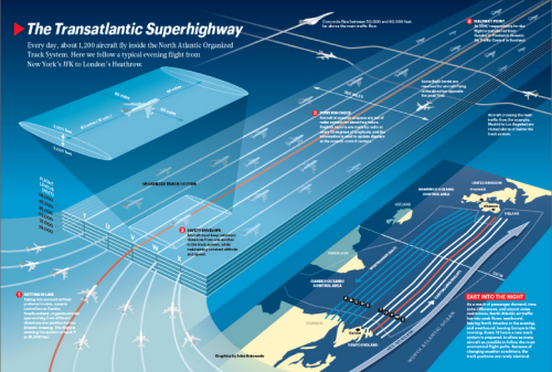
Abstract maps that take their subject and reproject into an imaginary space, distorting scale and reality can often bring clarity to a complex geography. Here, John Grimwade produces a map of the North Atlantic air traffic system for Condé Nast  magazine. He visualizes routes as a linear strip map from North America to Europe showing scheduled flights at their safe distance and altitude.

There’s far more going on in this map than first inspection reveals which makes it perfectly in tune with our cognitive processes. For instance, the layout of routes from bottom left in the lighter areas to the top right, the darker areas actually mimics the latitudinal difference as well as the fact most west-east flights operate during the night. There’s a visual association that we subconsciously recognize. The safety envelope in the upper left gives us detail that we can then transpose to other flights. The individual detail works well as a key for the rest of the flights and, of course, not every flight is shown so we build our own associations.

Sadly, the map still lists Concorde as an operational flight given the map was published in 1996. Concorde was retired from service in 2003 to the great regret of many.

The map detail is highly generalised. Colours are in balance and sympathy and as a diagrammatic map used to tell a very simple story it works perfectly.

MapCarte 199/365: Gifu by Hatsusaburo Yoshida, c.1940

MapCarte199_yoshida

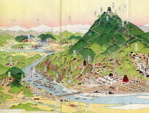
Long before satellite imagery and aerial photography, cartographers had to imagine the landscape and explore different ways of representing the world. Hatsusaburo Yoshida trained as a textile designer but is well known for his spectacular birds eye view maps, produced in the early to mid 1900s.

His work was informed by tireless local surveys which included not only measurements of the landscape but meetings with local people to gain a sense of what’s important to an area. This provided a way of developing a sense of what to include or omit on the map.

Yoshida’s maps are vibrant and colourful. They sow mountains as key features represented almost in aspect while much of the other detail is presented in perspective. There’s an abstract feel to the symbology and the clean lines used to represent real world features yet he manages to maintain a certain realism to the portrayal. The textual components use a billboard technique that lifts labels off the map which is a clever technique for this style of mapping. His skies and clear, cloudless sunsets illuminate the map to give it a crystal clear depiction unencumbered by haze or clouds.

Beautiful hand drawn maps showing the very best of design and representation. More examples of Yoshida’s work can be seen here.