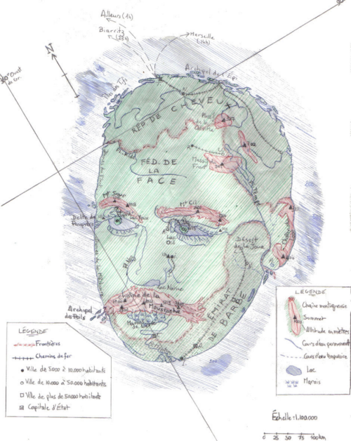
 It’s probably possible to make a map of just about anything and that includes the human form. The natural undulations and features of the body provide a rich terrain for people to let their cartographic juices loose on. Philip Gonzalvez did just that in this map of his face. In what has been referred to as ego-cartography, this map describes his facial features using map symbol metaphors.
The face is an island, strangely detached from its body but the usual green for land and blue for surrounding water provides the clear story that we’re looking at a man as an island. Prominent features are symbolised in a different colour to connotate elevation and a change in terrain with many other standard cartographic representations used to show discrete facial features such as the hairline as a border, eyes and nostrils as lakes and there’s even spot heights shown (and bathymetric depth noted). The République de Cheveux (Hair Republic) sits on the border of part of the Fleuve Ride (Wrinkle River), with the Fédération de la Face (Federation of the Face) beyond. There’s ports and ferry routes as well as all the usual map marginalia such as a graticule, north arrow, legend, border and scale, as both a representative fraction and scale bar.
The map even offers a cartographic joke as the meridian line dissecting the island is at 360 degrees west of GR. (Greenwich) which given that longitude is split into 360 degrees would place the map exactly back at Greenwich.
It’s whimsical and hand drawn. There’s nothing particularly exact but as an artistic representation, in map form, it clearly illustrates that map’s can be made of anything. As ubiquitous and recognisable objects, drawing another object in the style of a map doesn’t present a major challenge to the viewer…though perhaps intrigue and a fascination for how the artist has encoded their unique geography does.

