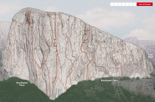
Click the image to view the web map
Maps that look simple often belie the effort that went into making them. The two related maps here, of El Capitan’s vertical structure, by National Geographic Magazine fall squarely into that category.
The first map by Martin Gamache and Lawson Parker, Scaling the Wall is a simple interactive map that illustrates some of the milestones of those that have conquered the wall. From 1958’s first major ascent to the newest route in 2010 (at thetime of creation of the map in 2011). The interactive map takes on the appearance of a photograph yet it’s a detailed computer generated image. It helps that El Capitan looks grey in real life but the colour provides a perfect neutral backdrop for the bright red ascent routes overplotted. Seven key routes are picked out but showing all routes reveals the detail of every route climbed on the 2,916 vertical feet. What a feat of human endurance and determination.
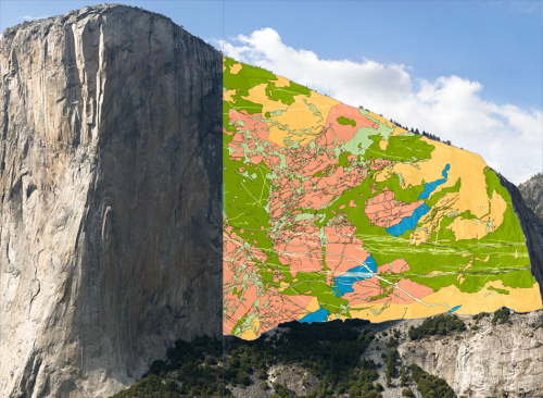
Click the image to view the web map
The second map by Roger Putnam contrasts the human activities of the first by illustrating the geology as an overlayed thematic layer. Putnam mapped the face himself using field notes and collecting samples to create the first ever high-resolution geological map of El Capitan. Previous surveys and maps had been compiled from surveyor’s visual assessment made from ground level using telescopes. Putnam’s work benefitted from a croudsourced approach ,where other climbers helped in climbing over 100 routes, as well as the collection of high-resolution GigaPan imagery and LiDAR surveys from ground level.
The 3D model built using GIS was then annotated to include detailed notes about the makeup of rock layers.One output, the resulting map of the geology of the face, illustrates over 850,000 points of data pin-pointed on a map build from the LiDAR data and GigaPan photos. The geological map has nothing but a legend and a swipe control to move the geologic overlay across a detailed photograph of the face.
These two maps are the result of a significant survey and scientific effort. Published as web maps with simple select and swipe controls, they give us a unique insight. Standing in Yosemite valley looking up at El Capitan is awe-inspiring enough for most of us but maps like these allow us to get up close and personal.


