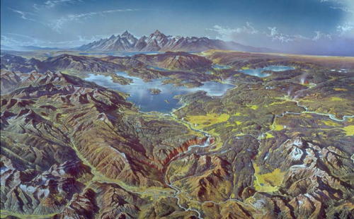
Heinrich Berann might be considered the father of panoramic style mapping. As a painter, he used his artistic talent to invent a new way of painting landscapes for the purposes of tourist mapping. His map of Yellowstone National Park, part of a set of four such works for the US National Park Service, captures Berann at the height of his abilities.
His work is meticulous in its attention to detail, uses highly saturated colours and a unique curved projection that mimics what might be seen (though exaggerated) from an aeroplane. The foreground of the map is almost planimetric which curves across away from the point of view to a horizon depicting the mountains in profile. The map is immediately pleasing to the eye and creates a unique sense of place that, for tourism mapping, is well suited to the need to attract visitors.
Berann also developed a trademark way of rendering cloudscapes which again, represent the sky in a way that is unlikely to be seen in the natural environment. In this sense, his panoramas are hidiously distorted in scale and representation but if the art of cartography is to capture a landscape and communicate something of its beauty then here, the distortions do their job superbly. His work has inspired many others…many of which we’ll showcase in MapCarte during the year.
More examples of Berann’s work appear on the web site showcasing his life and works here.

