MapCarte 238/365: Tracking Carbon Emissions by Stanford Kay, 2011

MapCarte238_carbon


Maps don’t have to look like maps though the further they veer from what we see as a traditional conceptualisation of space, the more people think of them in a different way. Terms such as diagram or infographic are commonly applied to maps that people don’t feel are worthy of the title ‘map’. Even Beck’s fantastic map of the London Underground polarises opinion with as many considering it a diagram.

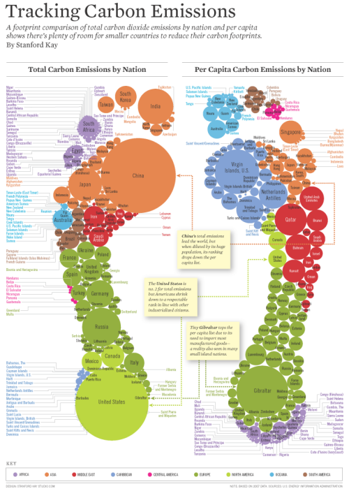
Stanford Kay’s effort in mapping carbon emissions almost certainly fits this mould. The metaphor is immediate as the shape of two footprints is a wonderful way of exploring the cost of our carbon footprint. The feet are made up of proportional circles showing the amount of carbon dioxide emissions per country. It’s a Dorling cartogram but it’s not entirely devoid of spatiality. The symbols are organised into broad regional areas so you get a sense of how different contries compare on a regional basis by simply recognising the colours. International comparison comes through exploring the different sized symbols and their labels.
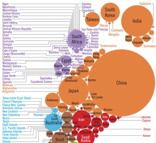
MapCarte238_carbon_detailCertainly this is at the heavily stylized end of the cartographic spectrum but it maps data represented spatially. The left foot shows us totals and the right foot reorganises the data per capita so we get two feet, each of which shows us a different aspect. Text is fairly limited but a nice touch is the linking of the countries labelled in list form with the symbols of the circles themselves.

The traditional shape of the outlines of projected countries gives way to a more powerful aesthetic. It’s a beautifully organised piece of work.We shouldn’t be afraid to make maps that use strong visual metaphors.

 

MapCarte 225/365: Is Barack Obama President? By The Guardian, 2012

MapCarte225_president

Infographics are all the rage. In fact, maps have always been information graphics. Sometimes, though, maps and mapping ideas can be used in extremely innovative ways to help create what might be termed a modern infographic.

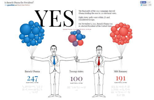
Take this illustration from The Guardian’s coverage of the 2012 Presidential election. It has the two candidates holding a handful of balloons. At first glance there’s very little map-like about this infographic but the balloons are, in fact, a Dorling cartogram. Each balloon represents a US state, coloured to show strength of vote, with the shared States being held by both candidates in the middle and the more partisan States being held well away from their opponent.

Each balloon is a perfect proportional circle and hovering over the balloon reveals further details.

MapCarte225_president_detail


The combination of illustration and the use of a statistical and highly abstract map form is a great way to present data in a new and interesting way and perfect for journalistic purposes.

The approach is supported by a clean look, effective typography and bold numbers to clearly inform the key facts. The balloons float into the screen and reorganise just as if filled with helium (or a metaphor for hot air perhaps?). There’s very little visual clutter on the page.

Take a look at the interactive version of the Obama map here or, for the sake of being equal, the Romney version here.

MapCarte 153/365: The distribution of voting, housing, employment and industrial composition in the 1983 General Election by Danny Dorling, 1991

MapCarte153_dorlingOne of Edward Tufte’s often repeated quotes goes something like this… “The world is complex, dynamic, multidimensional; the paper is static, flat. How are we to represent the rich visual world of experience and measurement on mere flatland?”.  Indeed, this problem is at the heart of cartography and becomes prominent when we’re looking to map multivariate thematic data. With a palette of points, lines and areas and a range of visual variables it’s often difficult to concoct a way to mp the data without seriously compromising something. It’s a challenge to represent complex data using simple, easy to decipher graphics.

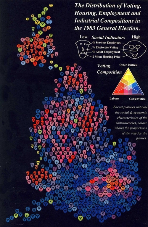
This example of a multivariate cartogram by Dorling does just that.  The cartogram that he created is based on the redistribution of proportional symbols such that they do not overlap. The underlying geographical structure is largely ignored though symbols are placed as close to their original position and in relation to their neighbours as possible. Here, the complex social landscape would normally be represented by a geometric symbol such as a circle which would be proportional to the population of the area they represent. Dorling goes one step further though by using Chernoff Faces to ascribe additional information.

Sizes of faces are proportional to the electorate and shape, eyes, nose and mouth each display additional socio-economic variables allowing a theoretical maximum of 625 different faces.  In reality only a fraction of these permutations exist, each coloured in one of 36 trivariate colours. Maps such as this require a clear legend. Dorling makes the legend larger to support the fact that this map requires readers to refer to it frequently. While this idea might be contrary to a lot of cartographic design theory (symbols should be capable of being interpreted with minimum recourse to the legend), such multivariate symbology needs clear unambiguous explanation.

The strength of the image is its overall impact as well as allowing readers to mine detail.  Faces evoke emotional reactions and show social differences we can easily interpret.  Sharp local divisions or gradual changes emerge.  While such glyphs can often overload a map image, Dorling combines them masterfully and the strong colours on a black background create additional contrast and impact and the recognisable shape of the Great Britain emerges.

Another of Tufte’s mantras is that you can symbolise complexity by giving detail. Here, Dorling makes a very efficient and simple looking graphic by providing a wealth of detail. It’s an art form to be able to represent complexity simply but maps can be very efficient ways of presenting multivariate data if done well.