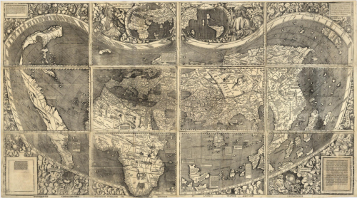
 Some maps transcend their perhaps modest original purpose and become something really quite special. This map, from 1507 was made in a small town in north-east France by a group of scholars led by Martin Waldseemüller. The map’s somewhat lengthy title “A map of the world according to the tradition of Ptolemy and the voyages of Amerigo Vespucci and others” is perhaps not the most efficient piece of cartographic design ever committed to paper but the map has many other important cartographic elements.
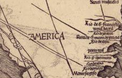
 Waldseemüller was very much influenced by the voyages of Vespucci who refuted the claims of Christopher Columbus that a series of newly discovered lands to the west were part of Asia. Indeed, Vespucci claimed them as a new continent and the name ‘America’ was born. Indeed, this is the first map to show and name the continent of America and which the U.S. Library of Congress paid $10 million to acquire from a German collector in 2003. It retains the mantle of being known as America’s birth certificate. As per the title, the cartography owes much to that of Ptolemy and is in fact the first to make use of Ptolemy’s new, second projection. However, Waldseemüller wasn’t afraid to alter the map to accommodate new knowledge and this was one of the first that broke the frame of a map to show the newly rounded Cape of Good Hope at the southern tip of Africa – a place that until now had been beyond the frame of Ptolemy’s projection.
As a woodcut, printed on 12 sheets of paper it also represents one of the most intricate and detailed maps of the period, and of many to come. Its detail is impressive for the time although there are many unresolved mysteries it gives rise to…including the question of how Waldseemüller knew of the Pacific Ocean 7 years before its discovery.
Undoubtedly one of the world’s most important cartographic artifacts but also one that shows great scientific influence and care for the aesthetic appearance.

