For cartographic purists there’s very little that matches a beautiful planimetric topographic map of a region. In many respects these are the maps that define the art and science of cartography because they are the standard-bearers for how we graphically describe the world around us. Those that are capable of crafting a beautiful topographic map have given us some wonderful, rich, detailed and beautiful examples. Often, the most visually impressive are of mountainous areas which demand that cartographers tackle the issue of elevation and relief. This is an art form in its own right.
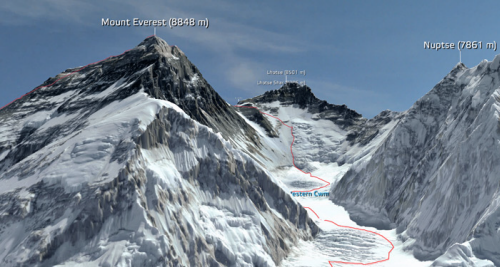
However, new technologies afford us different ways to view the world and in many of these remote, often highly dangerous, areas different approaches to data capture and map design are giving us new maps and new ways of seeing. Here, 3D RealityMaps have flown small planes over Mount Everest and filmed the landscape using a 3D camera. The captured footage allows researchers to build a 3D computerised model of Everest to 15cm resolution which can then be viewed through a downloadable app.
The model can be downloaded to explore allowing you to wander around Everest and follow many of the famous climbing routes, base camps and weather stations. The images are crisp and clear and have been expertly stiched together to create a seamless model of the mountain and its surroundings. The project also makes good use of satellite derived data to build a range of different components in the final map including WorldView-2, RapidEye, Landsat and ASTER. Some of this data was combined to provide surrounding coverage or to build a detailed terrain model to drape the primary imagery. Labels and annotated routes add to the detail of the work and enable the user to retrieve context to go with the pretty pictures. Photorealistic quality models and unrestricted navigation through a mountain region is made possible through the app.
This is modern surveying used to create a modern, engaging product. It’s a far cry to ground survey and planimetric mapping but it provides us with a way of looking at such a place that a traditional topographic map cannot similarly achieve. That’s not to say it top trumps topographic maps. It’s different. It adds to the canon of cartography.
You can explore and download the app at 3D RealityMaps here.


