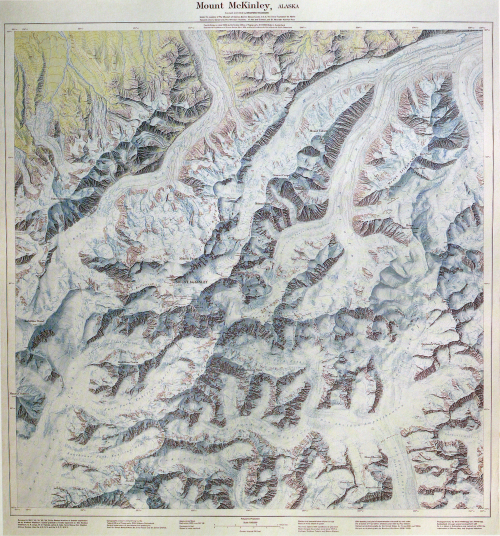
 Dr Bradford Washburn and his wife Barbara dedicated much of their life to exploration of many of the United States’ most extreme, inhospitable and uncharted environments. Their quest to study such landscapes in detail requires many months of effort and the results are brought to life and to the eyes of others through such sublime works as this map of Mount McKinley, Alaska – the highest mountain in the United States.
McKinley and the Washburns hold a number of firsts. Barbara Washburn was the first woman to climb McKinley’s North Peak. Bradford Washburn first climbed McKinley via the Muldrow route in 1942 and again in 1947. He was also the first to ascend the West Buttress in 1951 and led the first flights to capture aerial photographs of McKinley in 1936 for National Geographic Society. He was also the first person to land a helicopter in the mountain in 1949. It is this sort of dedication to understanding a place that gives the Washburn’s an unparalleled understanding. Many maps these days are constructed by people who have never visited the place they are mapping. They use secondary data sources. That’s not to say their work cannot be detailed and accurate yet the fact the Washburn’s spent over 200 days mapping McKinley’s terrain gave them a wealth of first hand knowledge to transfer to the map. That sort of knowledge is priceless in the attention to detail that a truly great map exhibits.
This is a masterpiece of topographic cartography, not just for the detail but also for the artistry in its presentation. Printed by the Swiss Federal Office of Topography the shaded relief is an example of the expertise in relief depiction we have come to expect from Swiss mapping. The relief on this map, though, goes a stage further and combines a range of soft shades of blue that give the map an ethereal feel of cold desolation. It creates an impression of atmospheric haze enveloping the mountain. The same colour palette is used for the contours so they sit within the design rather than becoming too prominent in their own right. The map is supposed to relay some of the realism of the place so the map’s contours are made to appear as much a part of the landscape as they can.
A perfect topographic map that combines artistry with scientific achievement and dedication.


Where can one find this map or was it in a book as well?