MapCarte 2/365: Wind Map by Hint.fm, 2012

MapCarte2_Wind

Click image to view the online web map

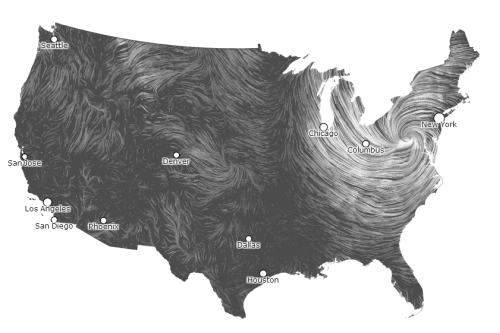
Fernanda Viégas and Martin Wattenberg (hint.fm), put together this wind map to illustrate wind patterns for the U.S. It’s as much an art project as it is a mapping effort but the lack of colour, clean UI and efficient interactivity makes this a modern classic. It spawned a more recent global example, Earth Wind Map by Cameron Beccario, but this was the first that used fine resolution animated lines to clearly connotate wind strength and direction. Great pan, zoom and hover controls and an animated legend add to the overall quality.

MapCarte 1/365: London Underground Pocket Railways map by Harry Beck, 1933

MapCarte1_Beck

A predictable start for the MapCarte series but let’s get it out the way…my personal favourite. A schematic diagram was Beck’s solution by which to map the London underground for navigation.  It’s a simplified and heavily generalised map consisting of stations, colour-coded straight line segments which run vertically, horizontally or at 45 degree diagonals.  Ordinary stations are differentiated from interchanges; the central area is exaggerated and external areas contracted.  The map shows no relationship to above ground geography other than the River Thames.  The same approach is still in use today by Transport for London, though the map has gone through countless revisions and design changes the core characteristics remain. Beauty in simplicity and a model for many transport related maps to this day.