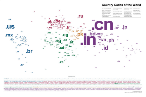
A map of the world’s top level country code domain names (as of 2008) that efficiently captures a number of pieces of information using some simple cartographic approaches. Locational information is encoded simply through the positioning of each label in the centre of the territory it relates to. There are no lines or boundaries on the map but because of the use of the label in this way we see the familiar shape of the world emerge. The sizing of labels helps this by varying according to relative population totals…with a contraction of China and India to enable them to fit the layout and a grouping of those countries under 10 million residents to avoid infinitesimally small type. The result is a proportional symbol map of population that uses text as both a literal and a scalable symbol. Colour is used to good effect to identify continents and as a visual link to the legend. Simple and abstract concept and a good example of the genre of maps whose form relies heavily on typography.
The map is available to buy as a high quality print here.


