
Click image to view the online web map
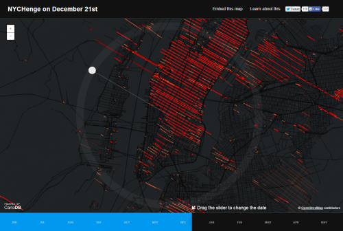
The Manhattan Solstice occurs twice a year when the setting sun aligns perfectly with the east-west street grid in New York City. This web map could not be any simpler but it captures the phenomena perfectly. Intuitive, interactive controls and a great use of colour allow viewers to explore the way in which the sun splashes across the city throughout the year. The minimalist approach simply places the linear symbols for sunlight across a dark background basemap. There’s no extraneous detail at all. The control of the sun angle can be moved by the map user creating a way to interact with the data to see how it shapes up across a year. Temporal data, perfectly represented with expert use of colour and contrast and a great example of using the web map medium to make a map that couldn’t be produced in other ways to the same effect.
