
Click the image to view web map
There’s a growing trend in contemporary cartography that is supporting the ability for easy and rapid re-styling of OpenStreetMap data. It’s a mapping equivalent of paint by numbers and we’ve featured one or two on MapCarte (e.g. Stamen’s Watercolor in MapCarte108 or Space Station Earth by Eleanor Lutz MapCarte 236). How long the current interest can sustain cartography is questionable because ultimately it’s someone else’s base data and the only outcome is a map of basic topographic detail, styled in a particular way. What purpose infinitely re-styled maps has is still open to question though they are giving people the ability to stretch their digital creative juices.
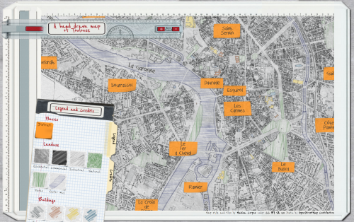
This example by Karl Azémar goes a step further than most as he creates a framework for the map by making it appear in a window with a border that suggests an draughtsman’s drawing table. The sliding ruler is a nice touch as it also holds the controls for zooming. The legend and credits panel is moveable and the map is well drawn…literally. The hand drawn pencil and coloured pencil effect is well developed using different line treatments and shaded fills akin to the sort of map one used to create in a geography workbook.
What lifts this map above similar pencil styled maps is the way Azémar has considered not only the layout of the entire map window but also the content that includes a treatment for the names using Post-It notes. It’s a good way to handle labels on this sort of map and he even uses different colours to denote different categories of city. There’s a lot of good cartographic hierarchy in this map.
You can read more about how the map was made here.
