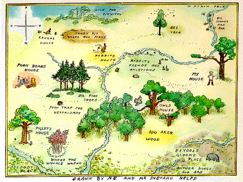
Maps of fictional places have always been ripe for cartographic depiction. One of the simplest, earliest and classiest is E. H. Shepard’s depiction of the fictional 100 Aker Wood in which the A. A. Milne children’s stories about Winnie-the-Pooh are set.
The map is small format and appears on the inside front covers of the books. As such, it immediately immerses the reader in the imaginary landscape providing settings for the many adventures. The map is whimsical and playful with the central characters being positioned throughout to depict them in the scene itself and even the north point is labelled POOH rather than NSEW. The imaginary wood is actually based on part of Ashdown Forest in Sussex, England. Many locations in the stories can be linked to real places in and around the forest. The landscapes were directly inspired by the distinctinctive high, open heathlands of heather, gorse, bracken and silver birch punctuated by hilltop clumps of pine trees. Both the map and Shepard’s other illustrations can be matched to actual views, allowing for a degree of artistic licence.
The map has become synonymous with the Winnie-the-Pooh stories and shows us that through maps, our imagination can be brought to life.


Pingback: MapCarte 287/365: City of Pop by Designliga, 2014 | Commission on Map Design
Pingback: MapCarte 313/365: The thrill of the chase wall map by Benchmark Maps, 2013 | Commission on Map Design